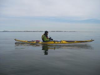
Sunday, March 27, 2016

S.I. Saw the Light(houses)

Last weekend I made it out to the lower harbor again, joined by my good friend MM and some mates she invited along from her New Jersy club. All were experienced sea paddlers. Weather was very gentle, with low winds and only partly cloudy. It was a bit chilly, but warmed quickly.

Our goal was to paddle to at least one lighthouse, and possibly a second one. West Bank Light sits about four miles off Staten Island, two miles south of Swinburne Island, which is where I went to see seals earlier this month. Another two miles further is Romer Shoal Light, which is actually closer to Sandy Hook than to Staten Island. Both mark very shallow waters, warning big ships to stay away and serving as markers for smaller vessels.

As it happens, one of our party has a son who knows the owner of Romer Shoal Light, and through such short degrees of separation we were able to get permission to land there. You know, just in case.

In short order, we rendezvoused at the north end of Roosevelt Boardwalk, portaged and kitted our boats, and set out for our destinations.

Setting out past Hoffman Island.

The Verrazano behind us, Manhattan in the distance.

The water was a bit chilly when we left, but as we paddled we got warmer, and the water seemed nothing against our skin.

We pulled past Swinburne, watched a couple of container ships drive through the Ambrose Channel, and took stock of the lower harbor.

We were definitely on open water.

West Bank Light.

The lower harbor is one of the few places in NYC where a New York paddler gets a sense of the open ocean. The rivers around Manhattan are a tidal estuary, to be sure, but there are plenty of landmarks and the shore is never more than half a mile away. Even in the upper harbor, trafficked as it is, there's still a sense of being in relatively sheltered water. It's just a large bowl, bounded by Brooklyn, New Jersey, and Staten Island.

The lower harbor is still sheltered but immensely broad. The exit to the sea is between Sandy Hook and Breezy Point in the Rockaways - five miles as the crow flies.

Beyond that is the open sea.

Closer to the Light(house).

Far Out.

Looking up.

We marveled at West Bank Light. Unmanned, it's still an impressive presence. There is something appealing about lighthouses, in their remoteness and resilience, something that inspires admiration in all mariners.

This part of the journey had only taken an hour, and we were all feeling nice and warmed up. The flat conditions - Sea State 1, technically but barely - invited us to journey on.

Onward to Romer Shoal.

Take a Break.

Make Adjustments.

Romer Shoal Light has a curious history. Originally the lighthouse was ashore and used for testing new methods of lighting. One of its keepers disappeared at sea when he set out for shore, leaving his assistant in charge until his body was found. At various points the light was operated by the US Navy, the Coast Guard, and eventually automated.

Now it's owned by a Staten Island businessman.

Romer Light, Worse for Wear.

At this point we'd been paddling for about an hour and a half and had at least two hours paddling to get back, not to mention breaking for lunch. One of our number floated the idea of landing, and I took that as a nudge to work on my "manage a group landing on rocks skills", notably, have the person in a plastic boat land first.

That would be me.

I scoped out various places to land. The tide surged about one to two feet in a cycle, not breaking in our protected cove, but adding some vertical challenge. It was also near low tide so we had slimy, slippery rocks, and none that really offered a flat surface.

I found a spot, popped my skirt, then pulled myself out quickly before grabbing my boat and, with a little finesse, lifting it up on the rocks.

I then helped MM, and brought her boat up, and with two ashore we were able to help the rest out quickly.


Shore Landing. Not shipwrecked!

Shore Party - for Lunch!

We took our lunch and watched a dredging tug come in from sea. We'd spotted hear earlier, a vessel with four distinctive stacks on the corners, to make her a platform in shallow-enough water. Done with her work, she was heading in. From our vantage, we could take in the sea, Coney Island, Staten Island, and Sandy Hook with equal east.

Interlopers on the way back.

We launched in reverse order of exit and paddled back towards Staten Island. The tide was slack and therefore not in our favor as had been the case on the way out, so the trip took a little longer.

On the way back we saw a different sort of voyageur.

Another way to view the seas.

I should mention too that we saw seals, but not as many as before because we were not near their winter home. They showed up late - L and R missed them, but MM and I spotted them and lagged behind trying to spot more - so long in fact that eventually L and R stopped and waited for us, took pictures of us, and only later noticed the seal in frame! The photos have been posted on the New York Kayak Company Facebook page.

Unpacking.

Once back, we un-kitted and put our boats back on cars, then drove to a German bierhaus and had smoked meats, potatoes, and beer. It was grand.

Always a lovely day at sea to make new friends and enjoy new views. I hope to make it out here more frequently once the weather is warm.

Wednesday, March 16, 2016

The Tubby Hook Paddle Compay

Dear friends,

I'm very happy to announce the formation of the Tubby Hook Paddle Company. Named for a local point of land that I often paddle near, "Tubby Hook", as I call it, will be the name under which I offer commercial instruction and guiding in the sea kayaking discipline.

You can see more about Tubby Hook at the website: www.tubbyhook.com, and also on Facebook (look for The Tubby Hook Paddle Company, or just https://www.facebook.com/tubbyhook). Tubby Hook provides small-class, bring-your-own-boat instruction and guiding for beginners and improvers in sea kayaking.

What's this mean for Kayak Cowgirl? Well, I'll continue to blog and post and twitterize and what-have-you about my adventures on waters near and far. Tubby Hook is meant to be something that can grow beyond the simple of adventures of a cowgirl in her trusty kayuse.

Kayak Cowgirl's always been about having fun in, on, and around the water. As I've moved into more commercial territory with lessons and guiding, Tubby Hook's the company that offers lessons and guiding in New York City and elsewhere.

I do expect to continue working at New York Kayak Company, and with friends at Brooklyn Kayak Guides and Prime Paddlesports, as well as club events at the Inwood Canoe Club. I also hope to continue my own development as a paddler, instructor, and guide at symposiums up and down the east coast. Ya'll should see me calendar for the summer and fall. One way or another, it'll all pan out.

There are some exciting events I would like to point out. A circumnavigation of Manhattan on June 12. A two-day ACA L2 coastal kayaking course June 18-19; assessment to come at a later date. I'll be attending the Hudson Valley Paddling Symposium weekend of July 24, followed by a strokes improvement course in moving water July 30. There will be some others, but those are the main ones.

I appreciate the support I've received from my audience (of mostly friends and family) and instructors, and hope to see many of you on the water in the coming months.

Cheers,

Julie K. McCoy
The Kayak Cowgirl


Wednesday, March 2, 2016

NY Seals

"Turecamo, Turecamo . . .hey captain, mind if I cut in front of you? We're just anchoring in Gravesend Bay. Or, you want me to wait, let you pass?"

We were in the lower harbor, directly across from Gravesend. One barge captain was talking to another, presumably outbound to inbound. The first captain wanted to know if he had time to pass in front of the incoming vessel and drop anchor. The captains worked it out - it turns out the other was heading in to the Bay Ridge anchorage, so they just altered courses to get closer to the eastern side of the channel.

Last weekend I accomplished a goal I've had for a few years now - to get out to Swinburne Island and see the seals there in winter. I do feel like I cheated a bit because I cartopped out there instead of paddling from Manhattan.

Except, wait a minute, hold on a tic - I have been out here before. Only this time, we spent more time on site, definitely saw some seals, and there was no hypoglycemia. Hurray!

I cartopped out from Inwood, along with friends from the Inwood Canoe Club in a separate car. The three of us drove down the West Side Highway, through the Brooklyn Battery Tunnel, down the BQE, and then across the big bridge at the narrows, and in short order we were at the north end of the boardwalk at the beach.

We were fortunate in the conditions for the day. Despite being the last weekend of February, the water was 40 F, air about the same, and winds were manageable at 8-10 knots from onshore. We were launching at about slack tide, and would have just a little current against us on the way back.

Our aim was Hoffman and Swinburne Islands. These are two manmade islands just off the coast of Staten Island, about a mile (two for Swinburne) south of the Verrazano Bridge and about a mile offshore, and west of the Ambrose Channel. These islands have their own fascinating history, better documented by others elsewhere, but basically were used as quarantine and military facilities until being abandoned.

Hoffman Island.

Unlike several other such islands in NYC though, they're managed by Gateway Recreation Area, a National Park that encompasses Sandy Hook, Bennet Field, and Fort Wadsworth on Staten Island. In fact, I'd gotten a good tip on where to launch from Ranger John D, whom I met last Fall at Bennet Field's welcome center when we went camping there.

Ranger John was right: those seals are hard to photograph!

A glimpse.

We paddled out, about forty minutes, over some mild waves. The wind was a bit stiffer than predicted but not unmanageable. We took in the view. Even if we didn't see seals, we saw the lower harbor, including Coney Island in the distance, a lighthouse, and Manhattan far to the north.

Eventually, I got some better shots. I had to take a pretty big risk for these. I'd put my camera in its waterproof housing at the beach, and I think they moisture captured fogged up the lens internally. At a certain point, I took my plucky little Powershot out and held it with three fingers, cupping my other hand under it, and stowing it in the Gore-Tex sleeve of my drysuit in transit. It was hair-raising, but it got better shots than if the foggy-witch of the sea had had her way.

The seals.

When we arrived, they scattered, but would show up behind each other. "There's one right behind you," we said repeatedly. In one view I counted five, and then two or three to my right. We floated along, pushed only by the wind and minimal current, and they took us in. One of them, larger than the rest, seemed to keep closer, ready to do something if we got suspicious.

We waited and watched.

The Narrows and Manhattan in background.

One our way back, a couple of them followed us. We were a good two miles out at least, and they followed us till we were just north of Hoffman Island - nearly a mile north of where we'd seen them of Swinburne. Satisfied that we weren't predators, they seemed genuinely curious about these 17-foot long creatures that swam only on the surface, with flippers in their midsection.

The seals look back.

Well, it was a bonnie day.

Sun glistening.

Of course when we landed, obligatory group photos ensued. Watch the container ship.


And maybe ignore the beachcomber !


This was a fun trip, one I hope to do again. Even in summer, sans seals, it is a fun location, with low, choppy waves, views of endless sea, and just enough nearby navigation markers to put fun exercises nearby.